Back مقاطعة سانديرز (مونتانا) Arabic Sanders County, Montana BAR Сандърс Bulgarian সান্ডার্স কাউন্টি, মন্টানা BPY Sanders Gông (Montana) CDO Sanders County CEB Sanders County, Montana Welsh Sanders County German Condado de Sanders Spanish Sanders konderria (Montana) Basque
47°40′N 115°08′W / 47.66°N 115.13°W
Sanders County | |
|---|---|
 | |
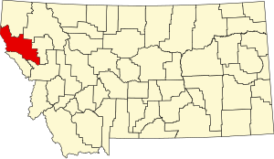
 Location within the U.S. state of Montana | |
 Montana's location within the U.S. | |
| Coordinates: 47°40′N 115°08′W / 47.66°N 115.13°W | |
| Country | |
| State | |
| Founded | 1905 |
| Named for | Wilbur Fiske Sanders |
| Seat | Thompson Falls |
| Largest city | Thompson Falls |
| Area | |
| • Total | 2,790 sq mi (7,200 km2) |
| • Land | 2,761 sq mi (7,150 km2) |
| • Water | 29 sq mi (80 km2) 1.1% |
| Population (2020) | |
| • Total | 12,400 |
| • Estimate (2022) | 13,442 |
| • Density | 4.4/sq mi (1.7/km2) |
| Time zone | UTC−7 (Mountain) |
| • Summer (DST) | UTC−6 (MDT) |
| Congressional district | 1st |
| Website | www |
| |
Sanders County is a county in the U.S. state of Montana. As of the 2020 census, the population was 12,400.[1] Its county seat is Thompson Falls.[2] The county was founded in 1905.[3]
It has an annual county fair with rodeo at Plains.[4]
- ^ "State & County QuickFacts". United States Census Bureau. Retrieved May 7, 2023.
- ^ "Find a County". National Association of Counties. Retrieved June 7, 2011.
- ^ Montana Place Names from Alzada to Zortman. Helena MT: Montana Historical Society Press. 2009. p. 236. ISBN 9780975919613.
- ^ "Sanders County Fair". Sanders County Fair Organization. Retrieved June 6, 2013.
© MMXXIII Rich X Search. We shall prevail. All rights reserved. Rich X Search